CREDITS: I would like to thank Jeremy D'Entremont for providing much of the history one can find on this site. He is a speaker, author, historian, and tour guide who is widely recognized as the foremost authority on the lighthouses of New England. For a story on Jeremy or to visit his site (New England Lighthouses: A Virtual Guide), use the corresponding link in the right hand information bar under "Related Links".

Search for Lighthouses

Introduction

I have set up this site as a means to share my photographs of lighthouses. Since retiring and finding more time to study photography, my interests have expanded a little. For some of my work other than lighthouses please enjoy my Facebook page at, John Shaw Photography. Come visit, enjoy, and 'LIKE' if you wish.

Also, for your enjoyment, I have provided a slideshow of our journey. To view it please use the link on the right under 'Site Navigation Tools'.


I sincerely hope you enjoy my efforts and use my site not only for information and education but also to provide directions for many enjoyable, inspirational visits to the beacons along our beautiful coas.

Thursday, May 17, 2012

Spring at the Coastal Maine Botanical Gardens #3

     This is the third in a series of posts.  As with most outstanding gardens, the Coastal Maine Botanical Gardens have numerous places where one meditate, contemplate life, or simply take a break.  Below are but a few examples of this:


Free Shuttle

      Thank you for visiting Maine Lighthouses and Beyond.  Please look for a couple more entries on Spring at The Coastal Maine Botanical Gardens.  I sincerely hope you enjoyed your visit with me.  I do enjoy sharing my work.

Wednesday, May 16, 2012

Fun With Macro: 2 Azalea Shots


     Thank you for visiting my site.  Please come back often and explore all there is here.

Tuesday, May 15, 2012

Spring at the Coastal Maine Botanical Gardens #2

     This is the second in a series of posts of photos taken on the day before Mother's Day 2012.  Please come back and see all of the coming posts.

The Rose Arbor

Lerner Garden of the Five Senses

Lerner Garden of the Five Senses

Lerner Garden of the Five Senses

Lerner Garden of the Five Senses

Lerner Garden of the Five Senses
      Thank you for allowing me to share some of my work with you.

Sunday, May 13, 2012

Spring at the Coastal Maine Botanical Gardens #1

     On the Saturday before Mother's Day my wife and I had an incredibly enjoyable visit at the Coastal Maine Botanical Gardens in Boothbay, Maine.  I honestly do not think it is possible to have a bad visit no matter the time of year.I tried very hard to take photos different from any I have posted in the past.  It really was not hard to do as the gardens are an ever evolving project.  I will split the ones I chose to take into three or four posts so as to not overwhelm those kind enough to come to my site in any one visit.  In this first post I will focus on their two main buildings.  I sincerely hope you enjoy my work as much as I enjoy sharing it.

     For more information on the gardens, please visit their site at,

Visitor's Center - Main Entrance

Inside the Visitor's Center

Heading Out of the Visitor's Center

Outside the Cafe of the Visitor's Center

Dining Area Outside the Cafe

Visitor's Center From the Gardens

The Front of the Bosarge Family Education Center

The Bosarge Family Education Center From the Garden Side

      I will follow this post with two or three more spaced a couple of days apart.  I hope you will visit often, spend some time while here, and enjoy all of the information I have compiled.  Thank you for coming!

Friday, May 11, 2012

The Children's Garden at the Coastal Maine Botanical Gardens

     Below is a very special shot taken by my daughter-in-law.  It shows just how beautiful the Children's Garden can be.  One can go there multiple times a year, each time seeing different flowers of the season, making each visit a unique experience.


Wednesday, May 9, 2012

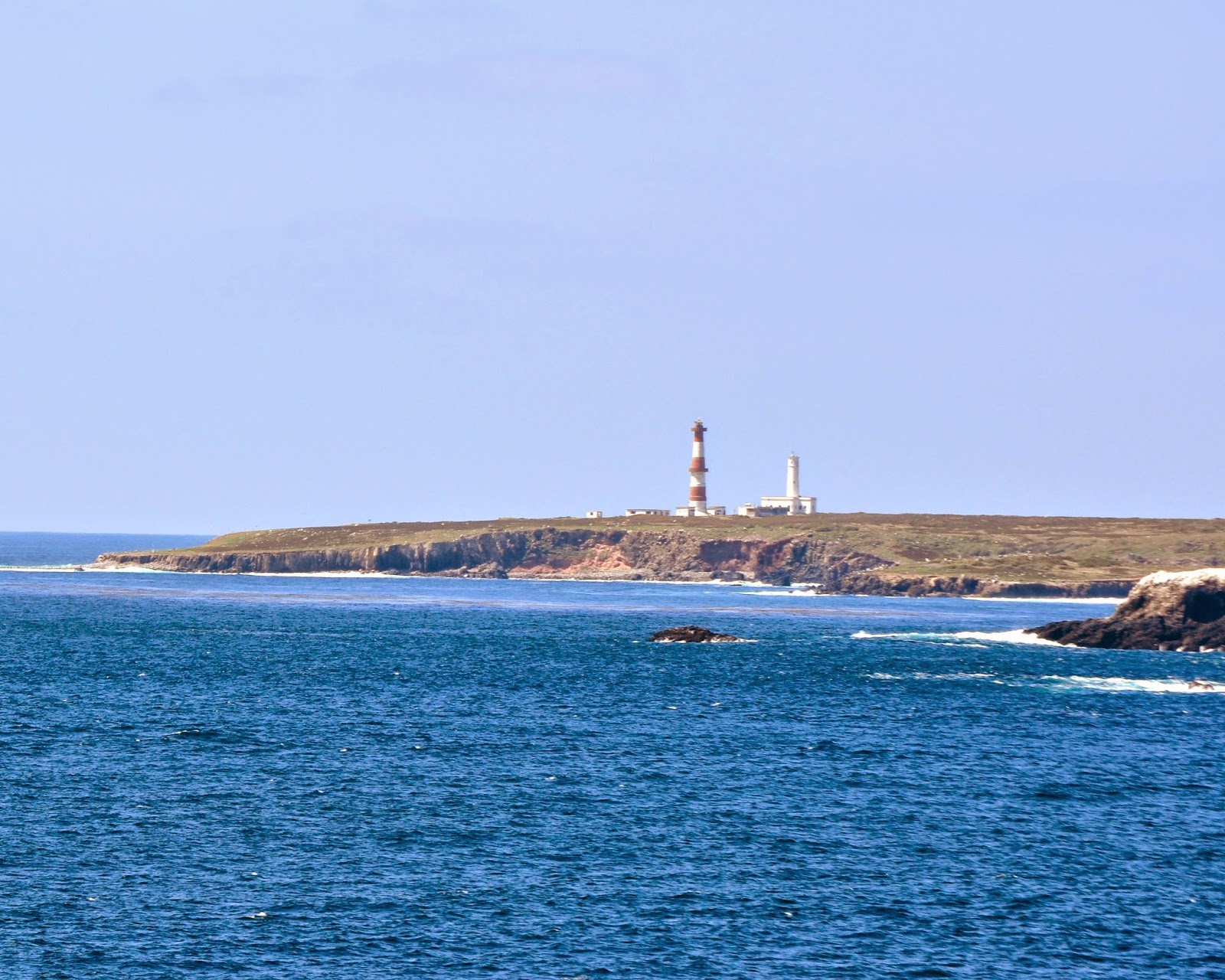
Faros de las Islas de Todos Santos (Lighthouses Near Ensenada, Mexico)

     The two lights are on the northwest tip of the northern of the two islands of Todos Santos, located in the Bahía de Ensenada about 20 km west of Ensenada. The islands are well known as a surfing site.


     One a stone tower, about 14 m (45 ft tall), attached to a 1-story stone keeper's house. The lighthouse is painted white and is inactive since thew lantern has been removed. The building was abandoned and deteriorating, but recently it has been renovated and repainted. 


     The other, painted with red and white horizontal bands is still active. It is a 98 foot concrete tower with two galleries, lantern and gallery.  A small clamshell Fresnel lens is in use. While the site is open, it is assessable only by boat.   


Go to Home Page

Tuesday, May 8, 2012

The Old Lahaina Lighthouse


      Between 1820 and 1860, Hawai`i was popular with whalers as a stopover point for refitting and reprovisioning. The high cost of supplies and port charges at Honolulu made Lahaina the port of choice for whale ships. To aid the ships in reaching the port, the first lighthouse in Hawai`i was constructed at Lahaina in 1840. The light was built on a section of waterfront known as Keawaiki that means literally “the small passage,” referring to a narrow break through the coral reef, which led to protected anchorage.

     The only existing record of the original lighthouse is a letter written from John Kapena of Lahaina to Paulo Kanoa in Honolulu. In the letter, Kapena describes the original light as a "tall looking box-like structure, about nine feet high and one foot wide, so was all sides; built on a suitable position facing the landing." It was positioned so the landing was marked for "those vessels, boats, and canoes that may come in port at night; because there were quite a number of boats wrecked by the waves." The lighthouse was first lit on November 4, 1840, and the keeper was paid a salary of $20 per year. The whaling ships using the port were charged $1 for the lighthouse, $10 for anchorage and pilotage, and $3 for water.

      In 1866, a third light was put into operation at Lahaina. Little information exists regarding the second light to serve the port, but some rough details concerning it are given in the following excerpt from the Hawaiian Gazette announcing the establishment of the third light.
The old Light House at this port has been pulled down, and a new one erected on the old site, somewhat enlarged. The old house was 19 feet by 25 feet, the new one is 25 feet by 30 feet, and a light tower built on top, containing a light room and a sleeping room for the light-keeper. The lamps are altered to burn kerosene oil, instead of whale oil.

     The storehouse below the light was leased to the owners of a sugar plantation at a rate of $96 per year.

     The Hawaiian monarchy was overthrown in 1893 by a group of armed businessmen who established a provincial government. The U.S. government officially annexed Hawai`i on July 7, 1898, but it would not be until 1904 that the government took control of the aids to navigation in the islands.


     Upon assuming control of this light in 1904, the Lighthouse Board wrote:
This is a fixed white light composed of two ordinary kitchen lamps of small power, with red and green sectors, estimated to be 20 feet above high water. The lights are shown from a white wooden pyramidal tower built on the top of a wooden storehouse. It is difficult to distinguish this light from the lights in the town.

     Due to the deficiency of this light, it was reconstructed in 1905. The new wooden, pyramidal, skeleton tower was fifty-five feet tall, thirty feet taller than its predecessor and had an enclosed workroom near the top, just below the lens platform. The lens lantern that replaced the two ordinary reflector lamps had red and white sectors. As long as a mariner remained in the white sector, a safe approach to the port could be made.


      In 1917, the wooden tower was replaced by the current thirty-nine foot, pyramidal, concrete tower at a cost of $1,549, which included improvements to the seawall. A metal ladder leads up one side of the tower to the platform from which a fixed red light is shown. The durability and ease of maintaining such concrete towers led to their wide deployment throughout the islands. A metal plaque placed at the tower in 1984 by the Lahaina Restoration Foundation, the caretakers for the lighthouse, gives a brief history of the towers built at the site, which was originally home to the "oldest Pacific lighthouse."


      In 2009, Coast Guard Senior Chief Petty Officer David Garrett and his crew from the Coast Guard Aids to Navigation Team in Honolulu converted the Lahaina Lighthouse to solar power, ending years of reliance on Maui Electric Co. This move, made possible by new developments in light-emitting diode (LED) technology, will eliminate power bills and allow the beacon to stay lit during power outages.

Go to Home Page

Saturday, May 5, 2012

Kuki'i Point Lighthouse in Nawiliwili on Kaua'i

      The Kuki'i Point Lighthouse, one of Hawaii's nondescript minor lighthouses, is located on the Kiele Course of the Kaua'i Lagoons Golf Courses.


     This navigational aid consists of a twenty-two-foot pyramidal, concrete tower that displays a white flash every 2.5 seconds at a focal plane of forty-seven feet.


     The Kuki'i Point Light was originally powered by acetylene gas and was maintained by the keeper of the Nawiliwili Lighthouse.


Go to Home Page

Friday, May 4, 2012

Nawiliwili Lighthouse on Ninini Point (on Kauai)

    Hawai`i's only navigable river, the Wailua River, is found on Kaua`i, however, no natural deepwater harbors exist along the island's entire coastline. To remedy this situation, a portion of Nawiliwili Bay, near Lihue, was dredged and protected by a breakwater to form Nawiliwili Harbor.
The origin of the name Nawiliwili is disputed. One claim is that it comes from Wiliwili trees, which once grew in the area. A more imaginative claim is that it comes from the profile, in the nearby Haupu Ridge, of Queen Victoria. According to tradition, the queen is shaking an admonishing forefinger at her unpredictable nephew, Kaiser Wilhelm, and saying "Now Wili Wili!"


     Nini Point, which marks the northern entrance to Nawiliwili Bay, was leased by the Hawaiian government from the Lihue Plantation in 1897 as a site for a lighthouse. Several light structures have served at the point over the years. The first was a wooden, frame tower, forty feet high and surmounted by a lamp room, which housed a light and reflector at an elevation of seventy feet above the sea.

     The light's first keeper, Manuel Souza, was born on the U.S. mainland to Portuguese parents. His future wife, also of Portuguese descent, came to Hawai`i from the island of Madeira as a contract laborer for a sugar plantation. Souza bought out her contract, and together they lived at the lighthouse for six years.

     Each evening before sunset, Souza would climb the tower, light the oil lamp, and place it along with its reflector behind the glass window that formed a corner of the small lamp room. The light would have to be tended during the night, and then around sunrise, Souza would extinguish the lamp, polish the reflector, and prepare the lamp for the next evening.


     Besides caring for the light, Souza also maintained the tower along with the keeper's house and grounds. For his efforts, he was given a meager monthly salary, which arrived irregularly forcing him to obtain credit from the local store to feed his family. In 1902, Souza wrote to the Hawaiian government with his grievances.

     I have been working steadily for five years in a place that is about 3 miles from any house or supplies. ... Can't my wages be raised for my present payment is too small to support my family. Besides my food, water costs me 50 cents a bucket and firewoods are the worst of all. I also spend my own money in preparing the lighthouse, such as painting it with white wash, etc. So with these few words I await your answer. P.S. Answer soon.

     His plea must not have been answered to his liking as Souza resigned the following year. Conditions at the station continued to degrade until the United States assumed control of Hawaii's navigational aids in 1904. In a report that year, the Lighthouse Board found that, "The lamp was out of repair, and the room on the tower needed to be rebuilt. ... The tower is dilapidated and unsafe. The dwelling is not fit for human habitation. There is no oilhouse."


     The original Nawiliwili trestle tower was torn down and replaced with a lens lantern atop a thirty-three and a half foot tall mast. The new light was first exhibited on December 22, 1906, and was rebuilt in 1923. As keeper, Oliver Kua would climb the mast to service the light each day via galvanized spikes set into both sides of the pole.

     As Nawiliwili Bay had become the principal port on Kaua`i, George Putnam, the Commissioner of Lighthouses, felt that the present station on Ninini Point was inadequate and requested that $48,100 be appropriated for a high-powered, long range lighthouse to served the harbor. The money was soon made available, and the present eighty-six -foot concrete tower was constructed in 1932 along with a new three-bedroom keeper's dwelling set on concrete block footings.

     During World War II, the Nawiliwili Lighthouse, along with all others in the Hawaiian Islands, was darkened. On December 31, 1941, a Japanese submarine surfaced near the entrance of the bay and shelled the harbor. Fortunately, several of the shells, including one that made a direct hit on a large gasoline storage tank, failed to explode and damage was limited to about $500. Fears of a possible Japanese invasion, led to the stationing of additional Coast Guard personnel at both the Nawiliwili and Kilauea light stations.

     The Nawiliwili Lighthouse was automated in 1953, however an attendant remained at the station and was responsible for routine maintenance of the Nawiliwili Light and seven minor lights on the island. The tower's fourth-order Fresnel lens was replaced by a DCB-36 beacon in 1984. The lantern room has been removed from the tower, compromising the structure's beauty.

Go to Home Page


Wednesday, May 2, 2012

Makapu'u Point Lighthouse on Oahu


     According to Hawaiian legend, Makapu`u was a supernatural being who, after arriving from Tahiti, took up residence on the point now bearing her name. This being's defining feature was her set of eight bright eyes, which is reflected in her name Makapu`u, Hawaiian for bulging eye. On October 1, 1909, the light from another bright, bulging eye was seen on the rocky point of Makapu`u as the giant lens in the Makapu`u lighthouse was illuminated for the first time.

    A petition, calling for the establishment of a light on the point, was signed by a number of sea captains and ship owners and presented to the Hawaiian government in 1888, after the American ship S. N. Castle had run aground in the area. Many thought the grounding would have been avoided if a light had been present on Makapu`u Point. Some preliminary planning for the lighthouse had been enacted by 1901, but when the territorial government learned that the U.S. Government would soon be assuming responsibility for navigational aids in the Islands, no further work was pursued.

     In January of 1906, a report stressing the importance of the Makapu`u Light was presented to the Fifty-ninth Congress.

     Makapuu Point is the extreme southeastern point of the island of Oahu. To the east of it is the Kaiwi Channel, which passes between the islands of Oahu and Molokai, which are about 25 miles apart. The harbor of Honolulu, the principal harbor of the central Pacific Ocean, is on the southern coast of Oahu, a short distance west of Makapuu Point. … There is no light on the entire northern coast of the Hawaiian Islands to guide ships or warn them as they approach those islands. The lack of such a light not only renders navigation at times very dangerous, but in bad weather or at night often compels them to slow down and await clear weather or daylight. With the increasing importance of commerce between the United States and the Hawaiian Islands, and the commerce passing the Hawaiian Islands and stopping at Honolulu, it will be very greatly to the advantage, speed, and safety of vessels that this much-needed aid to navigation be provided.
In June of 1906, Congress appropriated $60,000 for construction of the lighthouse. Any doubt that the light was truly necessary was eliminated when two months later the $2,500,000 passenger liner Manchuria ran aground off Makapu`u Point. After all passengers and most of the cargo were safely off-loaded, the steamer was finally pulled off the ledge that held her for almost a month and towed to Honolulu Harbor. The owners of the Manchuria were doubtlessly delighted that their ship was seaworthy again in less than two months, but they must have been equally frustrated since they had signed the 1888 petition for a lighthouse on Makapu`u, which would have almost certainly prevented the mishap.

      Makapu`u Point rises 647 feet above the ocean and is composed of a number of lava flows. The three keepers' dwellings, constructed of the abundant lava rock on the point, were built in a depression near the summit. At a height of 395 feet above the water, a notch, large enough to hold the lighthouse, was blasted out of the lava face. A trail linking the lighthouse and dwellings and a road connecting the station to the nearest highway had to be carved into the lava point.

     The thirty-five-foot tower was ready to receive its lens by October of 1908, but what size of lens to use in the tower was still being debated. Plans called for a third-order lens, then a second-order lens, and finally a first-order hyperradiant lens. The Lighthouse Board had purchased the 12-foot-tall lens, which had an inside diameter of roughly eight feet nine inches, in 1887. The lens was exhibited at the 1893 Chicago World's Fair, and then placed in storage for several years before being shipped to Oahu.

     Block and tackle was used to raise the numerous lens pieces from the deck of a ship, moored near the point, up the face of Makapu`u Point. The 1,188 glass prisms and brass framework were then assembled in the lantern room. The hyperradiant lens is the largest type of lens, and the only one of its kind used in a U.S. lighthouse.

     The lens produced a fixed white light, but a flashing characteristic was created by a set of copper panels that revolved on a track located between the light source and the lens. As seen from the water, the light was on for 7.5 seconds and off for 1.5 seconds. The weight that powered the mechanism for rotating the panels had to be wound every three and a half hours.

     An incandescent oil vapor lamp with three 55mm mantles was being used as the light source      when tragedy struck the Makapu`u station around 3:00 a.m. on April 9, 1925. The Lighthouse Bulletin of June 1, 1925 documented the incident.

     A cylindrical tank containing alcohol for starting the oil vapor lamp stood upright on a small wooden stand about six feet inside of the main entrance door on the left and about two feet above the floor. The first assistant suggested to the second that he fill the alcohol lighter, and after drawing all the alcohol which would run from the faucet, it was discovered that some of it had dripped on the floor. The first assistant lighted a match, which ignited the alcohol on the floor, and the explosion followed.

    The explosion blew the bottom out of the cylindrical tank. The second assistant keeper, John Kaohimaunu, was near the door and escaped with burns. The clothes of the first assistant, Alexander Toomey, caught fire, and the accident left him "charred black and crinkled." Toomey was transported to a hospital where he passed away at noon the following day. Before leaving the station, forty-year-old Toomey called his expectant wife and children to him, repeated the Lord's Prayer, and told his wife, "Stand by the light and keep it burning." It wasn't long before Toomey's wife gave birth to a baby daughter, and three months after the accident she died of a broken heart.
Hawaii's first radio beacon was installed at Makapu`u Point in 1927. The signal produced by the beacon could be picked up at a distance of two hundred miles and could be used to determine one's position. A generating plant was established on Makapu`u Point to provide electricity for the radio beacon, and the lighthouse was converted from oil-vapor to 500-watt incandescent electric lamps.

      Joe Pestrella became officer-in-charge at the Makapu`u Light Station in 1960, after a volcanic flow destroyed the keeper's quarters at Cape Kumukahi and that light was automated. During his service at Makapu`u, a seaman jumped ship from a merchant vessel that was passing the point. The man swam all night trying to reach the lighthouse. The following morning, Pestrella received word from the Coast Guard that the man was presumed dead. However, a few minutes later that man, now bruised and bleeding from pulling himself onto the wave-battered shore below the lighthouse, arrived at the Pestrella's home, where he received much needed first aid and food. In 1963, Pestrella, the last civilian member of the Lighthouse Service, retired after nearly twenty-nice years of service. The day before his retirement, he posed for a final photograph near the lighthouse.

     The Makapu`u Light Station was automated on January 4, 1974 by the Coast Guard, and was then monitored remotely from Honolulu. Sometime during the next year or so, the dwellings were secretly used to house prosecution witnesses during the trial of an underworld boss, who was facing federal tax evasion charges in Honolulu. In 1987, the government declared part of the land around the lighthouse and the keepers dwellings as surplus. The property was turned over to the state of Hawaii, but a group of armed Hawaiians took up residence in one of the dwellings as part of a land-ownership protest. After several weeks, the squatters were evicted without bloodshed, and shortly thereafter the dwellings were razed by the state. The only surviving outbuilding is an oil house near the trail that leads to the lighthouse.

     In 2001, the state of Hawaii paid $12.8 million for a large section of land around the Makapu`u Lighthouse. The acquisition allowed the state to improve parking near the trail leading to Makapu`u Point and should keep the coastline in the area free from development.

Go to Home Page


Monday, April 30, 2012

Diamond Head Lighthouse on Oahu

     The Diamond Head Lighthouse is a prominent symbol of Hawaiian history to residents and visitors alike. The lighthouse rests aside a tuff-cone volcano, formed by explosive eruptions thousands of years ago.

     In 1825, British sailors ascended the crater and found hard, clear calcite crystals among the black rocks. Mistaking them for diamonds, the sailors named the crater Diamond Head. Once of the Hawaiian names for Diamond Head is "leahi", meaning "wreath of fire". The name reflects the ancient Hawaiian practice of lighting a fire on the crest of the volcano to guide canoe fleets back to the island.

     The first lighthouse on this site was built in 1899. It was rebuilt in 1917 when cracks developed in the earlier structure. The Diamond Head Lighthouse still uses the original Fresnell Lens. The flash of a modern 1000-watt electric bulb is focused by the lens so it can be seen more than 18 miles out to sea.

     Located at the eastern end of Waikiki Beach, the Diamond Head Crater is a familiar landmark to the throngs of tourists who today pack the high-rise hotels in the area. For mariners of yesteryear, Diamond Head also served as a landmark for their approach to the harbor at Honolulu from the west coast of the United States.

     In the 1820s, sailors discovered what they believed were diamonds in the rocks on the volcano's slopes. Although the sailor's diamonds turned out to be clear calcite crystals, the name Diamond Head has been associated with the crater ever since.

     With the increase of commerce calling at the port of Honolulu, a lookout was established in 1878 on the seaward slopes of Diamond Head for spotting and reporting incoming vessels.

     During the night of October 2, 1893 the SS Miowera grounded on the reef just off Diamond Head. As Diamond Head was obscured that evening, the vessel's captain had mistaken the high land to the north of the crater as Diamond Head and had brought his ship too close to shore. All passengers and cargo were safely off-loaded, but it took six weeks to free the Miowera. Four years later, the magnificent steamship China also ran aground. It was widely believed that both of these incidents could have been avoided had a light been shown from Diamond Head.

     Captain James King, minister of the Interior for the Republic of Hawai`i, had been petitioning the Hawaiian legislature for a light on Diamond Head for several years, and according to the following account from the December 4, 1897 edition of the Pacific Commercial Advertiser steps were finally being taken to rectify the situation.

     Captain King became weary of hearing the pros and cons of the case, and after a few trips to the vicinity with Mr. Rowell, the Superintendent of Public Works, drove a stake for the site of the beacon. ... There was ordered at once the material for the illumination and for the towers. The iron for the structure has arrived and as soon as some road is made to the slope point, work on the structure will begin.


     The selected site was just 250 yards west of Charlie's lookout tower, and the original structure was a forty-foot-tall, iron, framework tower built by Honolulu Iron Works. Barbier and Benard of France manufactured the third-order Fresnel lens along with the lantern room for the tower. Due to concerns over the stability of the structure, the open framework was enclosed with walls constructed of coral-rock, excavated from a quarry on O`ahu. The light, which had a red sector to mark dangerous shoals and reefs, was first lit on July 1, 1899. A circular hole was left about midway up the tower so that Diamond Head Charlie could have an unobstructed view towards Barbers Point. John M. Kaukaliu was the first keeper of the Diamond Head Lighthouse, and as no keeper's dwelling was provided, he lived at a private residence about a quarter of a mile from the lighthouse.

     When the Lighthouse Board took control of all aids to navigation in the Hawaiian Islands in 1904, it reported that the Diamond Head Lighthouse was the only first-class lighthouse in the territory. However, during an inspection in 1916, it was noted that growing cracks in the structure were compromising the tower's integrity. In 1917, funds were allocated for constructing a fifty-five-foot tower of reinforced concrete on the original foundation.

    Scaffolding was built around the old tower and the original lantern room was removed and placed atop a new metal framework, allowing the continuous operation of the light. The old tower was then dismantled and replaced with the modern concrete structure, which strongly resembles the original tower. One notable difference is that the old tower had an external staircase that wrapped partway around the tower, whereas the new tower houses an internal, cast-iron, spiral stairway. When the tower was complete, the lantern room containing the Fresnel lens was placed atop the new lighthouse.

     The first keeper's dwelling at the station was built several yards west of the tower in 1921, three years after the new lighthouse was activated. Before that time, the keepers typically lived in a nearby village. A keeper occupied the dwelling for just three years, as the station was automated in 1924.

      During World War II, a Coast Guard radio station was housed in the keeper's dwelling, and a small structure was built on the seaward side of the tower. Following the war, the dwelling was remodeled and has since been home to the Commanders of the Fourteenth Coast Guard District.

     Besides continuing its nightly vigil over the reefs at Diamond Head, the lighthouse also serves as one end of the finish line for the biennial Transpac Yacht Race, which starts 2,225 miles away in Long Beach, California. During the race, members of the Transpacific Yacht Club are allowed to use the tower as a lookout for recording finishing times. The road near the lighthouse is packed with people watching the beautiful yachts, under full sail, riding the trade winds towards Honolulu. Even when there isn't a race to watch, the pullouts near the lighthouse offer amazing views of the surf and those who are drawn to ride it.

Sunday, April 29, 2012

The Aloha Tower Lighthouse in Honolulu, Ohau

     The second stop on our cruise was in Oahu where we found three much lighthouses that seemed much more traditional in structure.  The first, in Honolulu Harbor was the Aloha Tower lighthouse.


     On June 20, 1851, the House of Nobles and the House of Representatives of the Kingdom of Hawai'i passed an act, later signed by King Kamehameha III, for the establishment of lights for Honolulu Harbor. The provisions of the act, however, were never implemented, and in 1862-1863 the private sector led a campaign to raise funds for its own lighthouse at Honolulu Harbor to honor Captain James Cook. These efforts failed to produce a lighthouse as well, and it wasn’t until 1869 that real progress was made when the Hawaiian government purchased a small island near the harbor entrance to serve as the site for a lighthouse.

    Two bids were submitted for the harbor lighthouse. Honolulu Iron Works agreed to provide a lighthouse on iron pilings for $2,141, but a lower bid of $360, submitted by L. L. Gilbert for an all-wooden structure, was accepted. Wooden pilings were driven into the reef that formed the small island, and atop these a keeper’s residence and a square pyramidal lighthouse topped by a lantern room were constructed. Keeper Captain McGregor first exhibited the light from whale oil lamps, concentrated by a fourth-order Fresnel lens, on August 2, 1869.

     Though visible from a distance of nine miles and found to be quite useful to mariners, the lighthouse, which was given the nickname of the “Harbor Wink,” was called “an infantile structure which more resembles a birdcage than a lighthouse,” by Honolulu’s newspaper, the Pacific Commercial Advertiser. Working in conjunction with a light onshore, the maligned lighthouse also served as a front range light.

     The Honolulu Harbor Lighthouse was situated in the middle of the entrance channel, so ships carrying cargo to and from the port passed on either side. In 1875, the Reciprocity Treaty, a free trade agreement between the United States and Hawai'i, was ratified. This treaty greatly boosted the flow of sugar from Hawai'i to the United States, and pineapples became a second major export a few decades later.

     In 1906, after Hawai'i had become a territory of the United States and the Lighthouse Board had assumed control of the islands’ navigational aids, work began on a new entrance light for Honolulu Harbor. The Annual Report of the Department of Commerce and Labor records the following description of the second harbor lighthouse, which was located on Sand Island and first lit on February 15, 1910.


    The structure is rectangular in plan, one and a half stories high … The main floor contains quarters for two keepers, each provided with kitchen, living room, two bedrooms, and a bathroom. There are ample closets and pantries for each keeper. The main entrance and hall are approached from outside by a flight of concrete steps, and there are steps in the rear of the structure for both sets of quarters. The roof is framework, covered in metal tiles. Atop the keepers’ quarters is the square tower supporting: an occulting fourth-order lens, revolving on ball bearings.
Sixteen years after the new lighthouse commenced operation, a large-scale project was undertaken to provide a modern freight and passenger terminal at piers 8, 9, and 10 in Honolulu Harbor. As part of this project, a tower was constructed to provide offices for the harbor master, pilots, and customs officials. Honolulu Iron Works constructed the tower’s steel frame for $161,063, while the total cost for the twelve-story structure came to $190,000. The eleventh floor of the tower served as a lookout for the harbor pilots, with balconies on all four sides. Right below the balconies, the word ALOHA was spelled out in large letters, certainly the reason the structure was called the Aloha Tower. Besides its giant greeting displayed for arriving passengers, the tower, the tallest structure in Honolulu when it was finished in 1926, was also topped by a beacon to help captains enter the harbor.

     An article in the May 30, 1926 edition of the Honolulu Advertiser provided a detailed description of the tower, including the following lines on its beacon. “On top of the tower the harbor light, which is now located on Sand Island, is to be installed, and the light on Sand Island done away with. The light will be known as Honolulu Light, and will be visible to ships at sea for many miles.”

     Besides its light, the Aloha Tower had several other functional features. A giant clock face was   mounted on each of the tower’s faces, just below the ALOHAs. The master clock was powered mechanically by large weights suspended in the tower. If a ship or person was too far away to read the clock, two other means of time synchronization were provided. A time ball was lowered to the bottom of the forty-foot mast atop the tower each day at noon, and the blast of a siren was sounded at 7 a.m., noon, and 4 p.m. The novelty of the blasts was soon lost on nearby residents, and use of the siren was restricted to welcoming ships and warning residents of dangers from such sources as tsunamis and fires.

    A yardarm was also used atop the tower for signaling messages to mariners. When an orange ball and cone were both displayed, the harbor was closed. Right-of-way belonged to incoming ships when just the ball was displayed, and outgoing ships had the right-of-way when just the cone was present.
     The Aloha Tower received little damage during the bombing of Pearl Harbor, but shortly thereafter, it was camouflaged with brown and green paint, and its light was extinguished for the remainder of the war.

    A reopening celebration for the tower, which was returned to a uniform color, was held in 1948. By the late 1960s, tall hotels and business buildings were crowding the tower, and the Coast Guard decided to discontinue the beacon atop the Aloha Tower and install one on a 220-foot television tower. This navigational aid served until 1975, when the present Honolulu Harbor Light was established on a metal pole at the end of Pier 2.

     Ron Billian serviced navigational aids on Oahu from 1967 to 1969 as a BM2 in the Coast Guard. By the time of his service, the light had been moved from the Aloha Tower to the TV tower. Ron remembers how difficult it was to service the TV tower light. "It was one of the hardest and most dangerous lights to climb. There was a concrete base and you had to have a wooden step ladder. You would climb the ladder then step over onto a rung on the tower. The tower was round and rungs were on each side. Your legs had to be spread apart and you had to push up with your one leg and pull with your arms. We had a safety belt, and we wore it hooked to a metal pole running up the center of the tower. Once you got up to where the light was you had to unhook from the safety belt and step onto the platform where the light was - you would reverse the steps to come down. The danger was unhooking and rehooking from safety belt. I will confess I never made it up to the light. I'm 5ft. 7in. tall, and I didn't have the height or the strength to climb this tower. I tried more than once. We would get a sailor from the Coast Guard base that was also a diver, and he would climb the tower."

     Owned by the State of Hawai'i, the Aloha Tower was extensively renovated in 1994, at no cost to   taxpayers, by the developer of the adjacent Aloha Tower Marketplace.

Go to Home Page


Friday, April 27, 2012

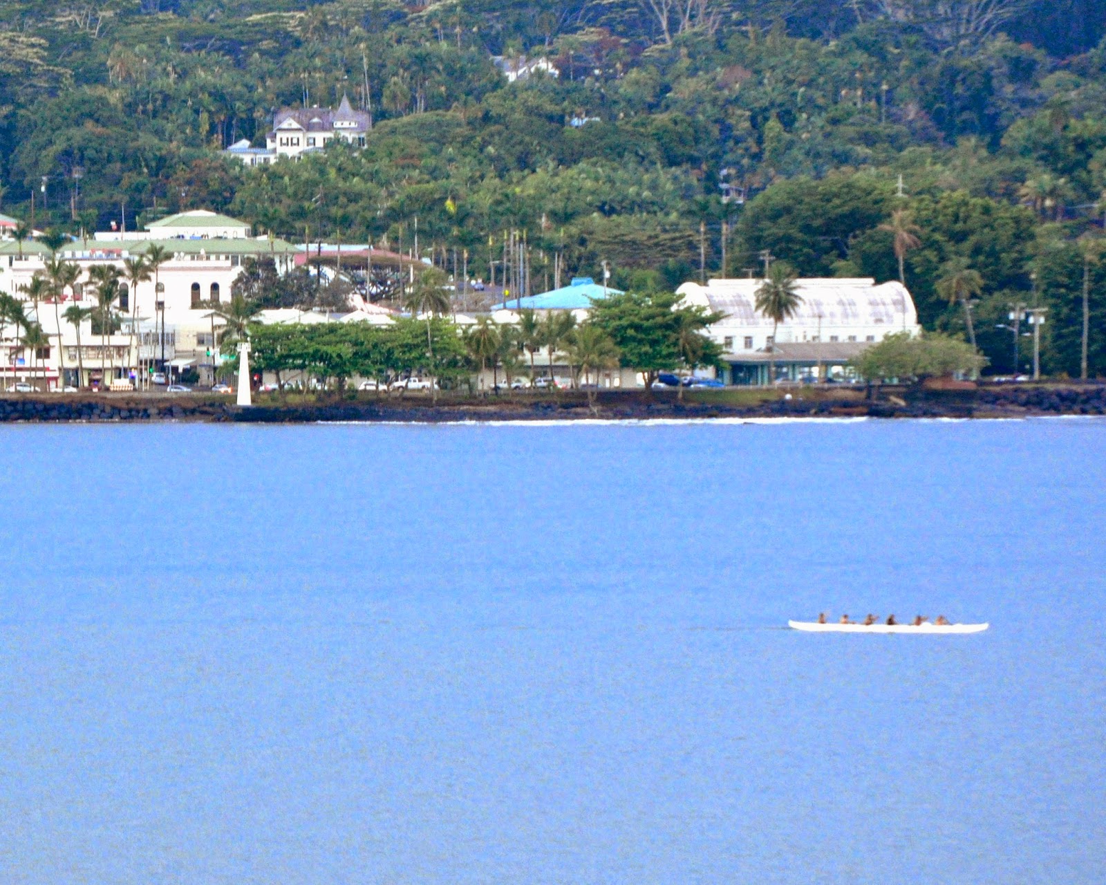
Coconut Point Lighthouse in Hilo, Hawaii

     Our first stop on our cruise to Hawaii is in Hilo on the island of Hawaii.  Like many of the in the Pacific, the Coconut Point Lighthouse is quite nondescript.  It is a simple, quite small tower with a small beacon on top.  Many of them are equipped with a green light as shown in the second photo below.


      The first beacon at Coconut Point was built by the Hawaiian government on the southwest shore of Hilo Bay and was tied to the city's electric lines. In 1904, when the Lighthouse Board assumed control of the navigational aids in Hawaii, a new lens lantern was installed at Coconut Point. The Board reported, "The present small fixed red lens lantern light, located on the old and dilapidated government wharf at the foot of Waianuenue Street, is entirely inadequate for the requirement of the growing trade of Hilo," and recommended that a new structure be built, as Hilo was deemed the second port of importance in the islands.

     The original tower was replaced by a concrete one in 1915, and the present thirty-four-foot pyramidal tower was erected in 1975. The signature of the Coconut Point Light is flashing green.

     A live shot of the Coconut Point Light can be seen in the video stream from the webcam mounted on top of the Pacific Tsunami Museum.